
Portfolio > On Location (UK) 3 > Port Mulgrave, North Yorkshire Coast Click on an image below to reveal enlarged version

Port Mulgrave, North Yorkshire Coast
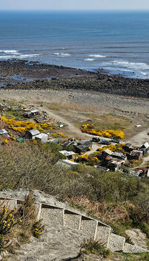
Port Mulgrave - a fascinating place. As soon as you reach the main gate at the top of the hill, you know you're in for something unique and it quickly becomes apparent when you find yourself shimmying down the embankment with the help of a rope! New steps have recently been installed, but they only travel two thirds of the way down the bank, which is when you're greeted by a rope. The rest is up to yourself.
When you do reach the bottom of the bank, with a sense of relief, you're then confronted with an almost apocalyptic settlement, which is very much like a deserted film set. There's corrugated iron sheds, abandoned tractors and boats, along with a sense of desolation and haunted existance. The place has a lot of fascinating history. In the 1850's Port Mulgrave was built as an industrial hub, to ship ironstone to the north-east.
Port Mulgrave is a derelict former ironstone exporting port on the North Yorkshire coast midway between Staithes and Runswick Bay in the civil parish of Hinderwell. Rows of domestic properties and individual houses exist on the top of the cliff. Historically the locality was known as Rosedale, but to avoid confusion with the ironstone mines and iron works at Rosedale in the middle of the North York Moors the area was renamed Port Mulgrave for the local landowner the Earl of Mulgrave.
In the 1850s Sir Charles Palmer opened an ironstone mine at Rosedale Wyke, Port Mulgrave with ironstone loaded onto small vessels from a wooden jetty. The barges were moved in and out using a paddle steamer.
The tunnel entrance at the harbour can still be seen but it is sealed up. In 1911 the pier gantry and boiler house were damaged by a serious fire however, the damage was repaired. In 1916 Grinkle Mine was connected to the Whitby, Redcar and Middlesbrough Union Railway thus avoiding the wartime hazards of shipping and the tramway tunnel abandoned. Port Mulgrave was a busy port for 40 years but the harbour was redundant by 1920 due to the railway link and cheaper foreign sources of ironstone becoming available. After falling into disuse the harbour was left to decay. In 1934 Grinkle Mine was abandoned, then the harbour machinery was sold off as scrap and the gantry accidentally destroyed by a fire. The west harbour breakwater wall was deliberately destroyed by the Royal Engineers to prevent its use as part of any German invasion during World War II.
The geology of the cliffs is Whitby Mudstone Formation (including alum shale) on top of Cleveland Ironstone Formation[10] with traces of Jet in the shale. The official access route to the beach is down a steep path leading to a wooden ladder. The cliff area is subject to coastal erosion, landslips and path closures, and the tide can cut off beach walkers. In 2022, the steps down to the beach collapsed during a landslip making it difficult for visitors to access safely. Ammonite, dinosaur and reptile fossils can be found on the foreshore and in the cliffs and because of this it is a Site of Special Scientific Interest. However, digging fossils out of the crumbling cliffs and screes is dangerous. The beach is composed of rock, sand and stones. The Cleveland Way walking route passes along the top of the cliff.


